Click here to Skip to main content
15,886,362 members
Everything / GIS

GIS

GIS

Great Reads

by mahmood kabi
extract overlapped polygons and calculate the overlapped area and write an API for it
by veen_rp
Geographic coordinates from decimal degree to degrees, minutes & seconds. And vice versa.
by veen_rp
Use and benchmark of coordinate transformation using the C++ proj4 library in VB.NET and C#
by DrABELL
Article describes concept/implementation of using novel Ultrabook™ features to extract and anylize road conditions and vehicle movement dynamics

Latest Articles

by mahmood kabi
extract overlapped polygons and calculate the overlapped area and write an API for it
by veen_rp
An add-on tip to articles already posted on Code Project
by veen_rp
Use and benchmark of coordinate transformation using the C++ proj4 library in VB.NET and C#
by veen_rp
Geographic coordinates from decimal degree to degrees, minutes & seconds. And vice versa.

All Articles

Sort by Score

GIS 

21 Oct 2017 by mahmood kabi
extract overlapped polygons and calculate the overlapped area and write an API for it
15 Jan 2016 by veen_rp
Geographic coordinates from decimal degree to degrees, minutes & seconds. And vice versa.
17 Jan 2016 by veen_rp
Use and benchmark of coordinate transformation using the C++ proj4 library in VB.NET and C#
17 Feb 2015 by DrABELL
Article describes concept/implementation of using novel Ultrabook™ features to extract and anylize road conditions and vehicle movement dynamics
23 Jun 2015 by DrABELL
Computational algorithms pertinent to finding the great-circle distance between 2 points on Earth
1 Sep 2017 by AnvilRanger
Sorry the people here are not going to do your homework for you. Your task is far too complex for anyone to solve in a simple QA post. If you have a specific question about something and have done the work then we will be happy to help. Off topic I will give you an important life lesson. You...
3 Feb 2015 by Member 10739055
I'm creating a plugin to mapwindow gis (using c#) with a map and a database. I was success in getting information from the map and showing it. But I couldn't update new data using a form coded with C#. Could you give me a way to add new data to attributes of shapes in the map?
24 Mar 2015 by Abhinav S
To build a map system like the ones you have mentioned, you will need a combination of these languages plus lots more.Writing GIS and Mapping Software for .NET[^] is simply an introduction to what you will need to proceed this task.
22 Jun 2015 by Khosro Moradaliyan
I want Load Map file(.shp) Offline in android and edit it.please help me
14 Jun 2016 by judoCoder11
Do you guys have an idea on how to put offline maps in vb.net for metadata or geotagging? We were planning to use the ArcGIS but it is not free. Please give us an idea on what free GIS plug-in or software to use in VB.net. We will use this for our project. Any help can do.What I have...
30 May 2016 by Peter Leow
Check this out: GMap.NET - Great Maps for Windows Forms & Presentation - Download: 1.7[^]
14 Jun 2016 by Sleeper 11888211
Try easyGISdotNET on this forum. It has lots of examples in C++. You can convert some code to VB yourself or use a C to VB translator. www.easygis.net is the link.
7 Jul 2016 by CPallini
Both are good (the choice heavily depends on the skills of the developer) and you might also mix them. Code development process could be a bit faster using C#, but, again, it depends on your skills and experience with such programming languages.
7 Jul 2016 by F-ES Sitecore
C++ would be faster, however the fact that you had to even ask this question makes me think the task is probably beyond your capabilities.
7 Jul 2016 by CPallini
This page suggests a positive answer: Appropriate Uses For SQLite[^].
7 Jul 2016 by Richard MacCutchan
You already posted this question at What is the best option for rendering and why (opengl, eyeshot, etc)[^]. Please do not repost.
7 Jul 2016 by Patrice T
The fact that you have to ask which language to use is an indication of your lack of skills and experience to conduct such a project.You can expect that actual AutoCad took more than 100 human year to get where it is today. Even limiting your self to 2D, a far cry from actual product, it is...
22 Feb 2017 by Nelek
You should use the message board at the bottom of the article. If you write there the authors will receive a notification. If they are still active, then they will probably answer you there.Here... quite difficult.
27 Mar 2017 by Richard MacCutchan
You need to post your question in the forum at the end of the article so the author can help you.
13 Jul 2018 by Sandeep Vemulapalli
I have one question on the TSQL Linked Server Query. Linked Server is GIS enforced so we pass the coordinates to that server which it returns the data from the Linked Server. Please find the below-working query. DECLARE @input varchar(max), @sql varchar(max); SET @input =...
13 Jul 2018 by Gerry Schmitz
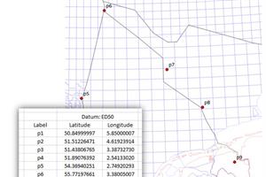
Your "before and after" single quotes "changed". You need to "simplify" your string handling so you get a better handle on what's happening. SET @b = geometry::STGeomFromText(''''POLYGON '+ @input + ' '''', 4326); SELECT @b = geometry::STGeomFromText(''''POLYGON ' + @input + @input2 + '' ',...
7 Dec 2018 by maysam_p82
Hi everyone . I'm going to write a windows service in python 27. There is a built-in function that mosaic picture tiles named arcpy.mosaicmanagement() . I want to give the function to a thread to work simultaneously. I have two problems: 1- I could run the program as a service in Windows, and...
29 Jun 2020 by maysam_p82
Hi , I have been struggling with a problem in asp.net application to connect to arcgis server 10.0 in Leaflet map using proxy. I can receive Token from server but after I login into the arcgis portal instead of seeing map layers I confront with...
21 Jul 2020 by Alireza Ghalavand
When I am trying to add a raster layer, I get this error from QgsRasterLayer::IsValid()!!! Can anybody tell me why this happens!? I am beginner in qgis, so could you please explain in detail. the first func "onAddLayer" used for Add button...
1 Dec 2020 by Gerry Schmitz
Creating HotSpots In ASP.NET Application[^]
29 Jun 2015 by DrABELL
Web app to find geographical coordinates and apply them to the Bing Map
31 Aug 2015 by kuzkok
Realization of leaflet plugin for editing spatial data
25 Sep 2014 by hamanyzaied
what languages i need to create website like Google maps and bing maps?
7 Jul 2016 by Member 12611495
Quote:Can SQLITE be used as the primary file in AUTOCAD application?What I have tried:Can SQLITE be used as the primary file in AUTOCAD application?
8 Apr 2014 by ravikhoda
Hi,i need to do some research on GIS based library for some web application. what i understand is that we open some shape file edit it and save it. for example we may create a map for showing rivers/roads or something like that. but how we can actually use it and what shape file actually...
8 Apr 2014 by Sergey Alexandrovich Kryukov
Look at their forum, ask the participants some particular questions on the topics you may be concerned with: http://forum.easygis.net/index.php[^].See also: http://www.easygisdotnet.com/[^].—SA
24 Mar 2015 by Sebastiaan Meijerink
But first you need to buy a box full of colorfull lego's
25 Mar 2015 by Aparna24
Esri GIS map used in an application can get displayed on IE but it dosen't on google chrome.
23 Nov 2015 by Member 11353899
I would like to geocode addresses in a SQL table using a ArcGIS geocoding service. The service is located here: http://gis.hennepin.us/arcgis/rest/services/Locators/HC_COMPOSITE/GeocodeServerI found a great example of what I am trying to do...
7 Jul 2016 by Member 12611495
Quote:Which programming language is good for developing CAD like application (Preferred is C#) - C++ has been suggested as fastest compared to C#. Can C# be used for this application, will it be as fast as application developed in c++.What I have tried:Which programming language is good...
7 Jul 2016 by Richard MacCutchan
Another repost of What is the best option for rendering and why (opengl, eyeshot, etc)[^]. Please stop doing this or you will find yourself removed from the site.